Nathalie Joyeux, Camille Pichot and Camille Serrisier
Participatory mapping, a tool for collaboration between citizens?
From the Michelin paper map to the successful Google Maps app, maps are part of our daily lives: going on holidays, joining friends, finding a restaurant, going to a concert. Whatever the nature of our needs and profiles, maps seem to be adaptable tools. Throughout the years, thanks to some redesign work on its aesthetics, ergonomics and contained data, maps are still being used. However, if we take a closer look, we will notice that in recent years, maps have gradually given way to cartography, and participatory cartography has emerged.
When we choose to talk about “cartography” rather than “maps”, we are highlighting the process of development and building of the map. Over the past fifteen years, the use of “participative mapping” has become increasingly popular. Gilles Palsky, who worked on the subject, noted in 2015 that “its occurrences only represented a few dozen on the main Internet search engines”, yet since then, there has been an explosion. For Palsky, “few maps are the product of an individual gesture”. With participatory mapping, he recognises that value is given to local knowledge based on “people’s experience or knowledge of the represented territory”. Participatory mapping is a “mapping of the inhabitants,
not in the strict sense of the term, relating to the ones who live there, but more broadly relating to the ones who make use of it” [1]. The knowledge of experts, their vocabulary and their codes are slowly replaced by the emotions, senses and memories of users. According to Catherine Didier-Fèvre and her colleagues, participative mapping is “a common project to build geographical knowledge”, along with being also a “huge enterprise, undertaken by citizens, to share knowledge” [2]. These methods, emerged throughout the last fifteen years under the influence of design thinking, rely on users’ expertise. As a consequence, these maps have a wide range of subjects: historical villages, unusual cultural places, indigenous knowledge, street-art, concerts, bicycles, electric scooters, car-sharing, complementary currency system, noise mapping… Even though more and more participative maps are being developed in apps using geolocation, it is not the only tool. Websites and walking are also used for participatory mapping. In participatory mapping, as in design thinking, there are different ways of doing things that lead to collaborative city projects. In this context of sharing, we may ask how has participatory mapping come to reconfigure our relationship with space and with others? In order to do this, we will question the participatory dimension conveyed by this new type of map and look closely at the issues it raises.
[1]Gilles PALSKY, 2013, « Cartographie participative, cartographie indisciplinée », L’information géographique, 2013/4, Vol. 77, pp.10-25
[2]Catherine DIDIER-FEVRE, Matthieu NOUCHER,2013, « Cartographie participative sur le net »,L’informationgéographique, 2013/4, Vol. 77, pp.149-
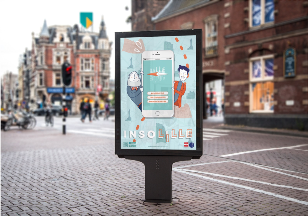
Insolille is a playful tourist project based on sharing unusual places of Lille. The application offers two modes: an explorer mode and a guide mode. It is thus possible to discover the city and its events through local stories or small challenges. The aim of the project is to create a social link between the city’s inhabitants and day-trippers, to eventually make of the city a new playground.
What lies behind participatory mapping?
The socioeconomic transformations experienced in the 60s disrupted completely our relationship with living spaces. While Lille gradually closed its industrial factories, the terms “representation crisis” or “decline of social ties” kept appearing in debates. Then, came the 80s, and participatory mapping started to develop. This type of mapping created by and for the people put an end to the monopoly of traditional mapping, until then produced only by experts and under precise rules (pictograms, IGN codifications…). The innovative aspects of participatory mapping are connected to design thinking. For instance, both are driven by co-creativity practices centred on the user and the constant research of new solutions.
As with design, participatory mapping opens up a completely new field of possibilities. They are for example very present in humanitarian aid, where they have become more popular among local communities than the official maps provided by humanitarian organisations. During hurricane Katrina in Sandy (New Orleans), it was a participatory mapping system that linked victims to volunteers.
Participatory mapping is also shaping our tourism practices, allowing us to discover hidden places, generally not found in traditional travel guides. In Lille, the on-going project Insolille (see Box 1) is a good example of this phenomenon: a mobile app in the shape of a treasure hunt linking its users, indicating the most unusual and unknown places in Lille and allowing to share anecdotes on these places.In this spirit, the power of participatory mapping goes beyond the simple geographic representation of space. Indeed, it reveals and highlights new knowledge, hitherto ignored, on what Guy di
Méo calls the “represented space” [3] of citizens, composed of their stories and practices in the area, adding a social dimension until now missing from traditional maping. This is the challenge taken up by the project la cartographie participative des cheminées d’usine (CPCU) meaning “the participatory mapping of factory chimneys”. The project uses participatory mapping to collect stories of Lille’s citizens on the city’s industrial chimneys, which have become real socio-historical totems.
The CPCU also illustrates the possible political contributions of participatory mapping. In this case, the creation process is often more significant than the produced result, another common point with design. “High Democratic Quality” design aims to develop the art of living together through common projects. This vision is inspired by the American philosopher John Dewey for whom democracy is defined by the “participation of individuals in collective actions” [4]. Thus, design and participatory mapping find common expression in their democratic dimension.
Indeed, the making of maps is often the opportunity for citizens to discuss their vision of the territory and sometimes of their development ideas. For instance, in Canada, the aboriginals of British Columbia (the Lil’wat), took part in an autochthonous participatory mapping. The main purpose was cultural and territorial re-appropriation of this minority, but on the same occasion, it gave them a form of recognition and legitimacy. Participatory mapping has thus an emancipatory potential. It allows individuals and communities to express their own vision of their living space. As a result, anyone can take part in the governance of the territory and participatory mapping creates a new connection between citizens and policy makers.
[1]Guy DI MEO, 1998, « De l’espace aux territoires :éléments pourunearchéologiedesconceptsfondamentauxdelagéographie », L’Information Géographique, n°62-3, pp. 99- 110
[2]John DEWEY, 1990, Démocratie et Education, Paris, Armand Colin et Nouveaux Horizons
Complications and challenges
Nevertheless, participatory mapping also has its issues. Multiple challenges face this desire to pool user’s and citizen’s knowledge rather than the experts’.
Participatory mapping is often based on the use of new technologies, mainly smartphones and their geolocation function. However, the same old problem regarding the exclusion of people cut off from technology arises, since a big part of society would then be kept out from the discovery of the city. This is one of the limits the Insolille project is facing. Because of this, it becomes even harder to give voice to the vulnerable population, who is not necessarily comfortable with technology.
Another issue is data collection. Participatory mapping is based on a bottom-up model wherein information comes from below, from the users. Nevertheless, to work within model requires a lot of data. The challenge then is to generate massive and sustained participation in order to collect enough data. This clearly is a limit that could jeopardize a project like Insolille. Faced with this challenge, CPCU organises a large number of workshops and projects to encourage loads of different people to participate, in addition to relying on the mass of information collected by associations interested in the memory of the territory’s industrial past. In this case, citizens do not lead the participatory mapping project, but they ensure its proper functioning. For any participatory mapping, another challenge is then to choose between citizen autonomy and professional and representative data collection.
Ultimately, the future of participatory mapping may not at all involve collective memory or unusual places. Mapping urban gardens [5], sustainable economy initiatives [6], local producers [7] or even shared vehicles [8] could be a way to make of participatory mapping a tool contributing to the ecological transition [9]. Melissa Viola Eitzel and her colleagues’ work [10], prove that the use of participatory mapping in the field of sustainable development can be an effective way to empower citizens. It is also an opportunity to encourage adults to continue to learn more about technologies and sustainable development, or to make them active players in the development of the city.
[1]Pour exemple, le projet « Gärten im Überblick » entre l’Allemagne et la Suisse
[2]Pour exemple, le projet « Réseau des Consommateurs Responsables »
[3]Pour exemple, le projet « Près de chez vous »
[4]Pour exemple, le projet « Belgique, mode d’emploi »
[5]Vinicia,2018,“10exemplesdecartographieparticipative”, [en ligne], https://vicinia.be/fr/10-exemples-cartographie- participative
[6] Melissa Viola EITZEL et al., 2018, “Sustainable development as successful technology transfer: Empowerment through teaching, learning, and using digital participatory mapping techniques in Mazvihwa, Zimbabwe”, Development Engineering, n° 3, pp. 196-208
La cartographie participative des cheminées d’usine (CPCU, participatory mapping of factory chimneys) is a walking map. It is based on the historical and social heritage, dear to North’s inhabitants: industrial chimneys.
The cartography collects people’s memory, creates a strong collaboration between associations and inhabitants, former passionate workers and just people walking by. Everyone is encouraged to participate in their own way (stories, videos, pictures, prospection…) to reclaim their heritage and their citizenship.
Finally, participatory mapping is a demanding, innovative process leading to new social dynamics. It requires the support, time and massive participation of citizens in order to collect enough data to make the produced map usable. Nevertheless, the strength of this approach lies in its ability to accommodate the diversity of uses and users of the territory while serving a variety of causes. Participatory mapping appears as a starting point to reintroduce the collective into the city, to encourage encounters and debate. In this sense, participatory mapping is quite similar to the design thinking methods, wherein collaboration, communication and co-creation are essential tools. Participatory mapping becomes thus an interesting tool for developing the collaborative city.
However, in order to make these maps more operational, it would be interesting to encourage greater cooperation among holders of participatory mapping, which would allow to solve major challenges relating to user participation and data collection. Furthermore, investing in the ecological transition would be a great opportunity to make participatory mapping a knowledge tool in the service of a major cause and for which citizen mobilisation is essential. So, let the future show us all the possibilities for participatory mapping.
An article written by Nathalie Joyeux, Camille Pichot and Camille Serrisier, three students of the public/private relations major at Sciences Po Lille.
Acknowledgements
Thanks to Fiona Lebre (co-designer of the POC Insolille) and Denis Plancque (project leader of the POC Cartographie Participative des Cheminées d’Usines) for giving us their time and attention during the interviews we conducted.
Nathalie Joyeux, Camille Pichot and Camille Serrisier